Understanding Aurora Province's waters: How can they be so treacherous?
On June 8, the Ateneo de Manila University men's basketball team held a team-building activity in Dipaculao, Aurora, at a resort where the waters are known to be aggressive. In a cruel twist, two of the athletes, Rene Baterbonia and Divine Adili, were pulled from waist-deep water toward the open sea, causing them to lose their lives.
Dipaculao officials have long warned visitors about its treacherous waters. What makes them dangerous?
The adjacent provinces of Aurora and Quezon lie on the East-Central side of Luzon. Feeding their waters is the Philippine Sea, which, in turn, is fed by the Pacific Ocean, the largest and deepest ocean on Earth. This ocean is wider than all the planet's landmasses put together and, in some parts, according to National Geographic, it stretches tens of thousands of feet deep.
Pacific Ocean's vast size allows winds to blow uninterrupted for thousands of kilometers, building energy and momentum to create strong rip currents.
This is the situation that greets visitors of the Aurora and Quezon shorelines. It's vital to understand the sort of water activity there is before going on a road trip to these provinces. While there are days when waves and currents are especially tall and strong, other days present relatively benign conditions.
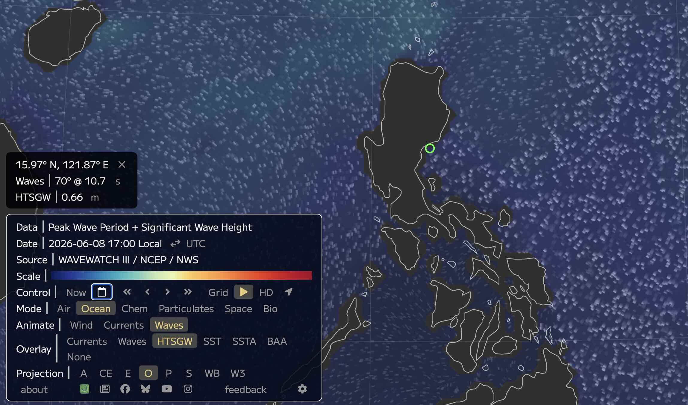
Data from Earth Nullschool, an online weather forecast shared by Laura T. David, Ph.D., professor and UP Marine Science Institute director, indicates that on the afternoon of June 8, when the Ateneo drowning incident occurred, waves by the coasts of Aurora and Quezon moved at a 70-degree angle from true north, with a 10.7-second interval between waves.
On the same afternoon, the height of the waves averaged 0.66 m, or about 2.16 feet, from trough to crest.
Tides, waves, and rip currents
David explained to PhilSTAR L!fe the different movements of the sea to better understand what to expect when traveling to the coastline.
Tides involve the up-and-down movement of the sea level, which happens every six to 12 hours.
"Kapag iniwan mo 'yung tsinelas mo sa beach malapit sa tubig, tapos three hours later and layo na niya, kailangan mo na maglakad na barefoot sa hot sand [para kunin], iyon ay dahil bumaba na ang tubig," David told L!fe, explaining the phenomenon of high tide and low tide.
On the other hand, waves are produced by the movement of energy in the water.
"Ito 'yung nakikita mong... paggalaw ng taas ng tubig kaya alam mo na ang nakikita mo ay dagat at hindi swimming pool," David said.
Demonstrating the result of its proximity to the Pacific Ocean, Baler, the provincial capital of Aurora, is a hotspot for surfers because of its towering waves in the Habagat season, reaching up to 10 feet, according to Surf Forecast.
Rip currents, often erroneously mistaken for rip tides, are strong, isolated currents going from the shore to the open ocean. These run perpendicularly or at an acute angle to the shoreline.
These are "caused by the concentration of water between sand bars, rocks, or any other underwater impediment," explained David.
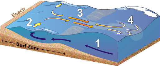
Per the National Oceanic and Atmospheric Administration, this is how a rip current forms: As incoming waves push water to the shoreline, it causes an imbalance of water levels in the surf zone. To regain balance, the water rushes to—or rips through—a path of least resistance, which is usually a break in the sandbar. The result is a strong motion that NOAA likens to a treadmill that carries people horizontally from the shoreline to the open sea.
A person with a high vantage point away from the shore will have a clearer view of a rip current compared to someone standing right in the surf. It will look like a patch of darker water extending away from the shore. Although it may appear harmless, a rip current can be unrelentingly strong.
Lifeguards have been known to refer to it as a "drowning machine" that is particularly life-threatening for inexperienced swimmers.
According to NOAA, rip currents, while appearing harmless on the water surface, can go as fast as one to two feet per second. Some particularly strong ones have gone at eight feet per second. Per NOAA's data, this is faster than any Olympian has ever swum. There have also been instances when several rip currents have formed simultaneously, varying in size and speed.
Gregory Dusek, a senior scientist with the Ocean Service at NOAA, warned that a rip current is most dangerous when waves are two to three feet high, even during seemingly good weather.
Initial findings from the investigation showed that it was a strong rip current that swept away the Ateneo players from the Dipalucao waters.
How to survive rip currents
There are several ways ocean swimmers, even casual beach goers, can prepare for possible rip currents, according to NOAA.
Watch for warning signs either on the beach or in weather forecasts. If there are none, ask lifeguards on duty about the surf conditions before entering the water. Even if they say it's safe, it's best for inexperienced swimmers and families with children to stay within the lifeguard's line of sight.
Avoid piers and jetties. Rip currents are particularly strong around them.
If you get caught in a rip current, the best thing to do is not panic, as this will waste energy and cause you to make wrong decisions. Remember that a rip current will not pull you under, Dusek reminded, just further out to sea. So rather than swimming against the current, float. Flip to your back and allow the current to carry you past breaking waves. It may also bring you back to shore.
If floating is not possible for you, see if you can swim parallel to the shoreline or toward breaking waves. Once you reach the break, swim at an angle to the shore.
Do your best to stay above water. This is so you can call or wave for help.