Heavy rainfall, flooding expected as Super Typhoon Uwan forecast to make landfall on Sunday evening
Heavy rainfall and possible flooding are expected as Super Typhoon Uwan is forecast to make landfall over Aurora on Nov. 9 evening or Nov. 10 early morning.
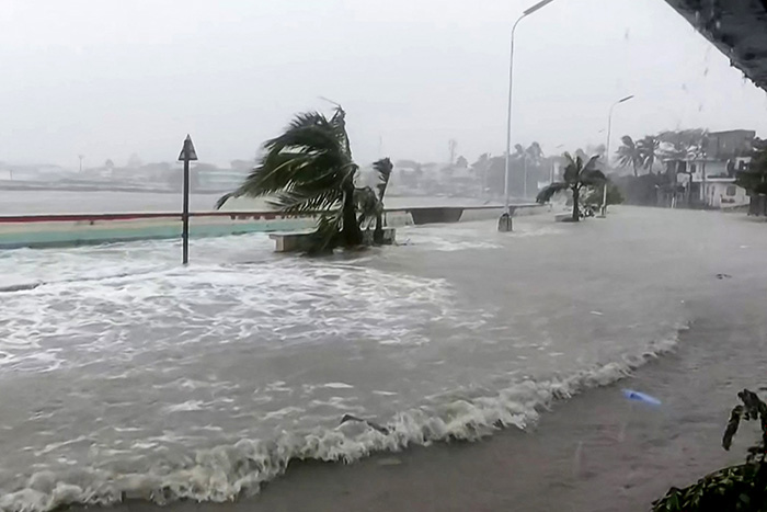
More than a million people have been evacuated, and at least one person has been killed as floodwaters rose on Sunday.
Rescuer Juniel Tagarino in Catbalogan City told AFP the body of a 64-year-old woman attempting to evacuate had been pulled from under debris and fallen trees.
With a radius spanning nearly the whole of the Philippines, Uwan is expected to bring wind and heavy rain to broad swathes of the country, which last week saw more than 220 people killed by Typhoon Tino.
Catanduanes has also been lashed by wind and rain already, with storm surges sending waves hurtling over streets and floodwaters rising in some areas.
Weather outlook
The Philippine Atmospheric, Geophysical and Astronomical Services Administration has issued a heavy rainfall warning, stating more than 200mm (nearly eight inches) of rainfall is expected in parts of Luzon, including Isabela, Quirino, Nueva Vizcaya, Kalinga, Mountain Province, Ifugao, Benguet, La Union, Zambales, Aurora, Nueva Ecija, Quezon, Bulacan, Camarines Norte, Camarines Sur, Catanduanes and Albay on Sunday evening until Monday afternoon.
These areas could potentially experience severe flooding and landslides.
Meanwhile, 100 to 200mm of rainfall could be encountered in Ilocos Norte, Pangasinan, Ilocos Sur, Cagayan, Apayao, Abra, Tarlac, Pampanga, Bataan, Metro Manila, Cavite, Batangas, Laguna, Rizal, Marinduque, Occidental Mindoro, Masbate, and Sorsogon until Monday afternoon.
These regions are likely to be hit with numerous flooding events and landslides in susceptible areas.
In Batanes, Oriental Mindoro, Romblon, Aklan, Capiz, Samar, Biliran, Northern Samar, Eastern Samar, and Leyte, about 50 to 100mm of rainfall is forecast.
These areas are expected to experience localized flooding and possibly, landslides.
PAGASA has also raised TCWS No. 5 in more areas, including the southern portion of Quirino, the southern portion of Nueva Vizcaya, the northeastern portion of Nueva Ecija, the central portion of Aurora, Polillo Islands, and the northern portion of Camarines Norte including Calaguas Islands.
Metro Manila remains under TCWS No. 3.
Additionally, a storm surge warning was issued at 2 p.m. over low-lying or exposed coastal communities of Cagayan Valley, Ilocos Region, Central Luzon, Metro Manila, CALABARZON, Marinduqe, Occidental Mindoro, Palawan, Camarines Norte, Camarines Sur, Albay, Sorsogon, Catanduanes, Burias Island, Northern Samar, Eastern Samar, Antique, Guimaras, Negros Occidental, Zamboanga del Norte, Zamboanga del Sur, Dinagat Islands, and Siargao and Bucas Grande Islands.
The center of the eye of Uwan was estimated 110 km north of Daet, Camarines Norte, or 150 km East of Infanta, Quezon.
It has maximum sustained winds of 185 kmh/h near the center, gustiness of up to 230 km/h, and central pressure of 935hPa.
Uwan's track
The weather state bureau said that heavy rainfall, severe winds, and storm surge may still be experienced far from the landfall point. Super Typhoon Uwan is expected to move northwestward over the next 24 hours.
The center of its eye will pass close to Polillo Islands before it makes landfall at or near its peak intensity over Aurora on Sunday evening or Monday morning.
"A direct hit over Calaguas and Polillo Islands is likely," PAGASA said.
It added that after landfall, Uwan will traverse the mountainous terrain of Northern Luzon and move toward Lingayen Gulf or the coastal waters of Pangasinan or La Union on Monday morning. PAGASA forecasts that it will remain a typhoon throughout its passage.
From Monday to Tuesday, Uwan will move northwestward and turn northeastward towards the Taiwan Straight as it weakens.
Class and number coding suspensions, free rides
Ahead of Severe Typhoon Uwan making landfall, President Ferdinand Marcos Jr. announced class suspensions for Nov. 10 and 11 in NCR, CAR, Regions I, II, III, IV-A, IV-B, V, VI, VII, VIII, and Negros Island.
Government work has also been postponed on Nov. 10 in NCR, Cordillera, CAR, Regions I, II, III, IV-A, IV-B, V, and VIII.
The Metropolitan Manila Development Authority has also halted the expanded number coding scheme for Nov. 10, while the Department of Transportation announced free LRT-1, LRT-2, and MRT-3 rides amid the super typhoon.
Super Typhoon Uwan comes just days after Typhoon Tino ravaged the country, particularly parts of Visayas, including Cebu, Dinagat Islands, Leyte, and Surigao del Norte.
To help those affected by the super typhoon, several malls are offering free overnight parking, charging stations, and WiFi.
Meanwhile, some establishments are offering relief through free meals, coffee, and shelter. (with reports from AFP)